Impact Flash Detection algorithm
(Edhah Munaibari, Master Thesis)
Summary: Lunar impact flashes are faint and fast luminous events, therefore it is of great importance the developemnt of efficient methods to identify them among 100s or 1000s of frames. To do so Edhah Munaibari, in the framework of his Master thesis (MAUCA, OCA), developed a new detection algorithm. The algorithm removes the inhomogeneous surface of the Moon and the earthshine and any potential luminous transient phenomenon should remain in the images. Then it can follow two different approaches for the detection: (i) It applies a threshold on the pixel values and multiple filters to ensure that it do not detect any artefacts; (ii) it applies a Gaussian filter that smooths most of the artefacts and eliminates them. Both approaches were tested in archived observations with success. The method is published here.
Automated Geolocation of Lunar Surface Impacts (AUGUR) algorithm
(Raven Larson, Master Thesis)
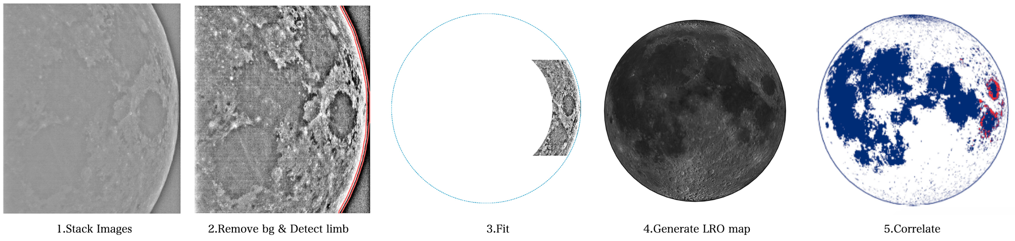
Summary: To identify the impact flash coordinates on the lunar surface is a very important step as on this depends the identification of the source of each meteoroids but also the discovery of the crater. AUGUR algorithm is developed in collaboration with University of Colorado Boulder by master student R. Larson. AUGUR initially stacks the images to bring out as many lunar features as possible and applies a low-pass filter. Then divides the stacked image by the blurred image to leave only the lunar features (basins, craters etc). Next the lunar limp is detected in order to fit a circle in the image. AUGUR uses the JPL Horizons database to pull information to generate a projection of the Moon for each event taking into account also the lunar librations. This projection is wrapped with the Moon LRO LROC WAC Global Morphology Mosaic to build a projected Moon. At the final step AUGUR correlates the LRO projection of the Moon of the epoch of the impact with the image of our observation. AUGUR is published here.
PyNAPLE (Python NAC Automatic Pair Lunar Evaluator) software pipeline
(Daniel Sheward, PhD Thesis)
Summary: PyNAPLE is the topic of the PhD thesis of Daniel Sheward who is collaborating with both Aberystwyth University and Observatoire de la Côte d'Azur. PyNAPLE uses images from the Narrow Angle Camera (NAC) onboard Lunar Reconnaissance Orbiter of NASA. The scientific goal is to detect the fresh craters on the lunar surface and link their diameter to the physical properties of the impactor meteoroids. This study is relevant to the science of dating the planetary surfaces as well as to planetary defence. The method is published here.